Key takeaways
- Sources that quote IEC TS 62446-3 (EPJ, Sitemark, DTU slides) give plane-of-array irradiance above 600 W/m2. IEA PVPS Task 13 recommends the same level.
- The standard’s free preview lists 3 cm of module edge per pixel at most, which it equates to 5 x 5 pixels on a 6-inch cell. One paper applies 5 x 5 pixels to every cell size.
- For a DJI Zenmuse H20T, 5 x 5 pixels per cell allows 36.0 m (160 mm cell) or 21.5 m (half cell). Adding 3 cm per pixel cuts the 160 mm limit to 33.8 m.
- The US limit of 400 ft (121.9 m) is far higher, so resolution sets your flight height.
- IEA PVPS Task 13 says the standard has no pass or fail limits, so your report must set its own severity bands.
To compare tools that detect, grade and report thermal faults, see the best solar drone inspection software.
Drone inspection at a glance
| Item | Detail |
|---|---|
| Formula | GSD = pixel pitch ÷ focal length × distance to the module |
| Conditions as quoted | Plane-of-array irradiance above 600 W/m2. Wind below 28 km/h (DTU). 3 cm per pixel or finer (standard preview, EPJ, Sitemark). 5 x 5 pixels per cell (ISES paper, the standard ties 5 x 5 to a 6-inch cell) |
| Where it matters | O&M surveys, fault finding and handover. Infrared is an extra test for larger systems in the commissioning report |
| Standard | IEC TS 62446-3 (2017 edition): guidance for outdoor infrared thermography, with no pass or fail limits (IEA PVPS Task 13) |
| In software | Image analysis and reporting tools. Flight planning sits in drone apps |
Why does drone inspection matter for installers?
In ideal conditions, IEA PVPS Task 13 gives 5 to 10 hours by drone for a 4 MWp plant, against 15 to 20 handheld.
It appears at handover, as an extra test for larger systems, and in O&M work. A report that names the failed string and its GPS position turns a vague yield drop into a repair ticket.
Design-phase drone work is a different job. Those surveys build 3D models. See drone site survey and photogrammetry.
What does a thermal drone inspection find?
It finds parts that run hotter than similar neighbours. These can be single cells, a third of a module, or whole strings.
- Hot spot: Raptor Maps defines it as an anomalous spot on a cell. IEA PVPS Task 13 links hot spots to local short circuits or poor cell contacts.
- Bypass diode: Raptor Maps says a diode anomaly means a bypass diode has activated, typically affecting about a third of the module. See bypass diode failure.
- String outage: Raptor Maps describes a fault across contiguous modules that match the string layout. IEA PVPS Task 13 notes that disconnected parts run hotter because the energy becomes heat.
- Severity: many Raptor Maps anomaly types have Low (under 10°C above adjacent areas), Medium (10 to 20°C) and High (over 20°C) versions.
Not every fault shows. A 2025 DTU test of 43 modules with induced faults found cell cracks only 1 to 2°C warmer at higher irradiance. PID modules with about 5% power loss showed no thermal anomaly.
What conditions does IEC TS 62446-3 set?
The standard asks for plane-of-array irradiance above 600 W/m2 and fine pixels. We read only its free preview, which shows the pixel rule. The irradiance and wind figures come from sources that cite the standard.
- Irradiance: above 600 W/m2 in the plane of the array. EPJ Photovoltaics (2025), the ISES 2025 paper and Sitemark tie it to the standard. IEA PVPS Task 13 (2018) recommends it.
- Wind: below 28 km/h, listed in the 2025 DTU paper and slides.
- Resolution: the free preview of the standard (Table 1, IR camera requirements) says "max. 3 cm of the module edge per pixel". A footnote says this equals 5 x 5 pixels on a 6-inch cell. EPJ, Sitemark and the DTU slides repeat 3 cm as a maximum, though EPJ also calls it a minimum once. The ISES paper says at least 5 x 5 pixels per cell, including views up to 30°. IEA PVPS Task 13 gives 5 x 5 as a distance limit but names a different, future standard (IEC 60904-3).
- Status: IEA PVPS Task 13 calls it instructional, not pass or fail. It ends with reporting requirements and a table linking thermal images to failure modes.
Lower light can still work for some faults. In the DTU test, shorted bypass diodes stayed visible at 200 W/m2. Cracks were not reliably detectable.
How do you calculate GSD and flight height?
Ground sample distance (GSD) is the module width one thermal pixel covers. It equals pixel pitch ÷ focal length × distance.
- Find the angle per pixel: pixel pitch ÷ focal length. For the H20T, 12 µm ÷ 13.5 mm is 0.889 mrad.
- Multiply by the distance to the module. Each metre adds 0.889 mm of GSD.
- Divide the cell’s shorter side by the pixels you need. That is the largest GSD allowed.
- Divide that GSD by 0.889 mm per metre to get the longest distance.
- If the camera is off the module’s normal, the pixel stretches by 1 ÷ cos(angle). At 30° the distance shrinks by 13% (a factor of 0.866).
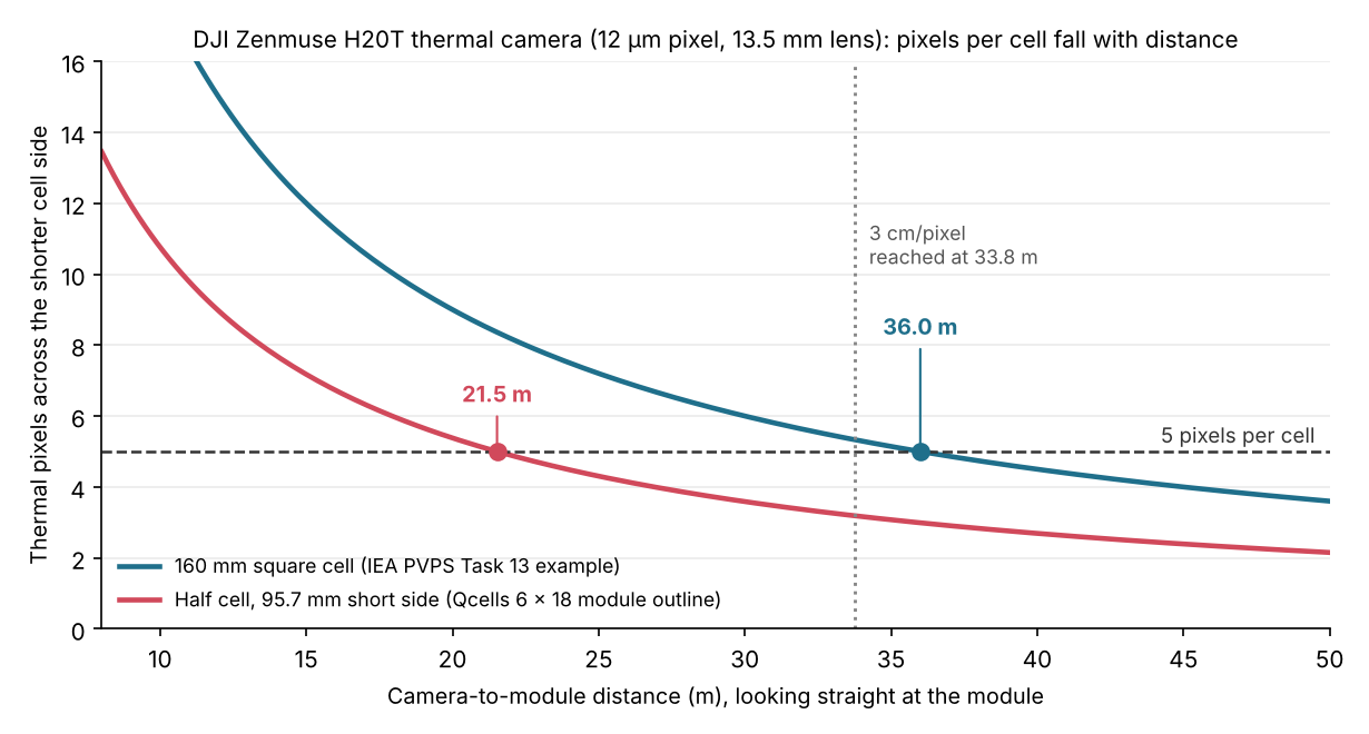
Figure 1. A half-cell module needs the drone 14.5 m closer than a 160 mm cell for the same 5 pixels. For half cells, the 5-pixel rule is stricter than 3 cm per pixel.
Worked example: a 640 x 512 thermal camera
Camera: DJI Zenmuse H20T thermal (640 x 512, 12 µm pitch, 13.5 mm lens, per DJI’s specs page). Module: Qcells Q.TRON BLK M-G2+, 1722 x 1134 mm with 6 x 18 half cells (datasheet Rev06_NA 2025-03, a North American variant). Straight-on view.
The half-cell module fails the pixel rule at a shorter distance than the larger cell. The first table covers the 160 mm cell.
| Distance (m) | GSD (mm/pixel) | Pixels across a 160 mm cell | 5 x 5 on 160 mm cell? | 3 cm/pixel? |
|---|---|---|---|---|
| 15 | 13.3 | 12.0 | Yes | Yes |
| 20 | 17.8 | 9.0 | Yes | Yes |
| 25 | 22.2 | 7.2 | Yes | Yes |
| 30 | 26.7 | 6.0 | Yes | Yes |
| 35 | 31.1 | 5.1 | Yes | No |
The same distances for the half-cell module:
| Distance (m) | Pixels across the half cell | 5 x 5 on half cell? |
|---|---|---|
| 15 | 7.2 | Yes |
| 20 | 5.4 | Yes |
| 25 | 4.3 | No |
| 30 | 3.6 | No |
| 35 | 3.1 | No |
The 160 mm cell is the size in IEA PVPS Task 13’s worked example. The half-cell side is 95.7 mm, the module length divided by 18. That includes frame and gaps, so the true cell is a little smaller and the limit a little lower than 21.5 m. The datasheet does not print the cell size. DJI’s 40.6° diagonal field of view implies a 13.3 mm lens, 1.5% shorter than listed, so GSD could be 1.5% higher.
At 21.5 m one image covers about 12.2 m by 9.8 m. The longest distance that meets both rules is 21.5 m for the half cell and 33.8 m for the 160 mm cell. Both are far below 121.9 m (400 ft). Pixels limit you, not the FAA ceiling.
GSD and flight distance calculator
Enter your camera’s pixel pitch and lens, the cell size and the distance. You get GSD, pixels per cell and the longest distance that meets both quoted rules. Use it as a design aid. It does not replace the standard.
What goes in a drone inspection defect report?
A defect report ties each anomaly to a place, a temperature rise and the conditions at the time. The standard’s report table is not free to read, so this list comes from IEA PVPS Task 13 and company documents.
- Array data: tilt, orientation and string layout (IEA PVPS Task 13).
- Location: GPS coordinates for each anomaly, matched to the string plan (IEA PVPS Task 13).
- Weather: irradiance and wind at flight time. Sitemark says the standard asks for on-site weather readings.
- Finding: anomaly type, temperature rise over similar parts and a severity level, as Raptor Maps and Scopito document.
- Analyst: IEA PVPS Task 13 refers to ISO 9712 Level 2 qualification for the analyst.
- Capture details: camera, GSD and flight date. This is our addition, so a reviewer can check the resolution.
Which US drone rules apply?
Flights under Part 107 are capped at 400 ft above ground level, unless the drone stays near a structure. Read the current text before every job. Rules outside the US are not covered here.
- Height (14 CFR 107.51): up to 400 ft above ground. Within 400 ft of a structure, up to 400 ft above its top. Visibility must be at least 3 statute miles. Clouds must be 500 ft below and 2,000 ft away horizontally. The eCFR showed no changes to this section since 3 January 2017 (checked 22 October 2026).
- Pilot and waivers: the FAA says Part 107 operation needs a remote pilot certificate with a small UAS rating. Waivers can be requested, for example for flights beyond visual line of sight (FAA page dated 6 July 2026).
- Not covered: Remote ID and airspace authorisation. Both can apply to a US job, so check the FAA Part 107 page in Sources.
- Part 108: an article dated 5 October 2026 reports no final Part 108 rule yet, and an Airdata article from July 2026 says the same. Both treat waivers as the route beyond visual line of sight for now. Check the FAA before a flight beyond visual line of sight.
How solar software handles drone inspection
Only Scopito and Zeitview document reports with severity levels on the pages read, and flight height or GSD guidance is rarely given as numbers.
| Software | Finds and reports thermal defects? | Source |
|---|---|---|
| Raptor Maps | Partly | Anomaly glossary (© 2025). Blog updated 14 May 2020. October 2026 |
| DroneDeploy | Partly | Help pages updated 25 March and 1 April 2026. Solar page undated |
| Scopito | Yes | Solar inspection software page, updated 17 November 2025 |
| Zeitview | Yes | Solar page, undated, October 2026 |
| Scanifly | Not stated | Product page modified 24 June 2026 |
Partly: the page covers some defect finding or reporting. Not stated: the company page we cite does not say. The Zeitview and Scanifly pages give no flight or GSD guidance.
- Raptor Maps: glossary of 41 anomaly types, many with Low, Medium and High temperature variants. Inspection reports were not shown on the pages read. A 2020 blog says GSD follows the inspection level and gives no figure.
- DroneDeploy: radiometric thermal processing (Enterprise plan) and annotations to mark deficient panels. The help page describes no automated detection or reports. The thermal flight planning page lists supported drones, no altitude or GSD values.
- Scopito: AI and human analysis. Diode, hotspot, string and backsheet findings. Severity levels. PDF and CSV reports. It links to a capture guide. No values on the page.
- Zeitview: inspection service plus Asset Insights software. Reports with annotated imagery and severity. Names overheating modules, string imbalances and outages.
- Scanifly: DroneDesign builds a 3D site model for design. No thermal or defect inspection on the page read.
Tools that detect, grade and report thermal faults are ranked in the best solar drone inspection software list.
Common mistakes with drone inspection
FAQs
What irradiance do you need for a drone thermal inspection?
Sources quoting IEC TS 62446-3 give plane-of-array irradiance above 600 W/m2. Some faults show earlier: in the DTU test, shorted bypass diodes were still visible at 200 W/m2.
What ground sample distance do you need?
The standard’s free preview sets 3 cm of module edge per pixel at most, which it equates to 5 x 5 pixels on a 6-inch cell. One paper applies 5 x 5 pixels to every cell. In our H20T example, a half-cell module needs a distance of up to 21.5 m. A 160 mm cell allows up to 36.0 m on pixels alone, or 33.8 m once 3 cm per pixel also applies.
How high can a drone fly over a solar plant in the US?
Part 107 allows up to 400 ft above ground, or 400 ft above a structure when within 400 ft of it. For thermal work, resolution usually forces you much lower, up to 21.5 m in our example.
Does IEC TS 62446-3 give pass or fail limits?
IEA PVPS Task 13 says it does not. It is guidance, with reporting requirements and a table linking thermal patterns to failure modes. You set the severity bands, as Raptor Maps does with its 10°C and 20°C steps.
Can a drone find a failed bypass diode?
Yes in many cases, but studies differ on how strong the signal is. IEA PVPS Task 13 describes only a slight rise for short-circuited diodes. In DTU’s 2025 test of induced faults, the difference reached 20°C on one module at above 800 W/m2. Hotspots on a two-diode module exceeded 70°C.
Related terms
- Thermal inspection: finding faults from infrared images.
- Hotspot: a module area running hotter than its neighbours.
- IEC 62446-3: the thermography guidance standard.
Next step: pick a thermal inspection and reporting tool from the best solar drone inspection software list.
Sources
All sources checked October 2026. IEC TS 62446-3: only the free preview was read, not the full text.
- Conditions and defects. IEC TS 62446-3:2017, free preview from iTeh (checked 30 October 2026). IEA PVPS Task 13, Review on IR and EL Imaging for PV Field Applications (2018). del Prado Santamaría et al., EPJ Photovoltaics 16, 31 (2025). Spataru, IEA PVPS slides (2025). Teodoro et al., ISES SWC2025. Sitemark blog (2021).
- Equipment. DJI Zenmuse H20 series specs. Qcells Q.TRON BLK M-G2+ datasheet, Rev06_NA 2025-03.
- US rules. eCFR, 14 CFR 107.51. FAA, Part 107 page. The Drone U, 5 October 2026. Airdata, Part 108 explainer, July 2026 (checked 30 October 2026).
- Software. Raptor Maps: anomaly glossary and flight blog. DroneDeploy: thermal mapping, thermal flight planning and solar page. Scopito. Zeitview. Scanifly.
Last updated 30 October 2026. Next scheduled review: 30 January 2027.