Key takeaways
- Of 7 AHJ documents, 6 name roof pathway or setback features and 6 a main bus or breaker rating. Only 2 name roof pitch, and none names shade.
- Absent from a checklist does not mean unused. GreenLancer says layout needs pitch, azimuth and shade, and structural review needs framing.
- On a 6:12 roof, plan area is 10.6% below sloped area. Misreading the rise by 0.25 to 0.5 in moved area by 0.4% to 1.7% in our cases.
- Of 6 software tools, 1 documents capturing structural, electrical and property data in a field app. The other 5 document part of the job.
To capture these items in the field, see the best solar site survey apps.
Site survey at a glance
A site survey records the measured inputs a design needs. The AHJ decides what the permit set must show.
| Item | Detail |
|---|---|
| Formula | Pitch (x:12) = 12 × rise ÷ run. Sloped area = plan area × √(1 + (rise ÷ run)²), which is plan area ÷ cos(angle). |
| Unit / typical range | Inches and feet. Our four sample faces run from 2:12 to 10:12, with slope factors of 1.014 to 1.302. |
| Where it matters | Layout, roof and site plans, single line diagram, structural letter, bill of materials, proposal. |
| Standard or rule | No national format. The AHJ’s checklist and the engineer’s needs decide. |
| In software | Field apps capture, imagery tools measure remotely, and design tools receive the data. |
Why does a site survey matter for installers?
A survey decides whether the design you sold can be built and approved. GreenLancer says it "turns preliminary assumptions into verified design inputs".
A wrong pitch or a missed vent changes the module count after the customer has signed. A wrong bus rating changes the breaker on the single line diagram. See the permit plan set page for how mismatches fail review.
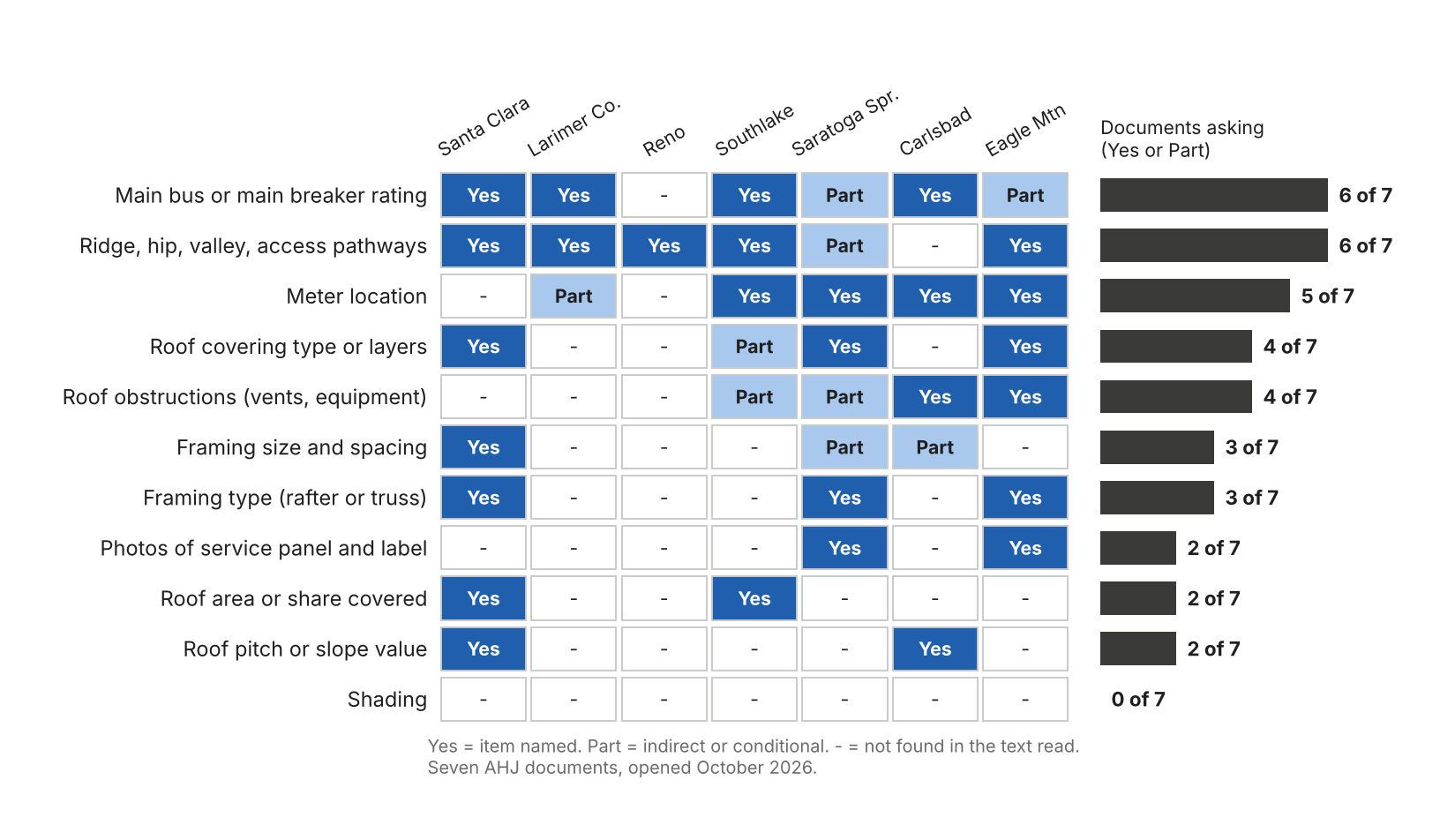
Figure 1. No item appears in all seven documents. Pathways and setbacks lead with six, pitch has two and shade none.
Counts are from the seven documents opened, read as text summaries. A dash means not found, not proven absent.
What does a site survey capture, and which document needs each item?
A residential survey records eleven kinds of data. Each feeds one or more of the permit set, single line diagram, bill of materials (BOM) and panel layout. The notes below the table give the permit counts and sources.
| Survey item | What to record | Needed by |
|---|---|---|
| 1 Roof planes | Length, width and azimuth of each plane. Roof area. | Layout, permit roof plan, BOM |
| 2 Pitch | Rise per 12 in, per face. | Layout, structural letter, permit, BOM |
| 3 Roof covering | Type, layers, age, damage, sagging. | Permit, structural review, BOM (flashing) |
| 4 Framing | Rafter or truss, size, spacing, span. Attic views where reachable. | Structural letter, BOM (attachments), permit |
| 5 Main panel and breaker | Bus rating, main breaker, spare positions, label photo. | Single line diagram, interconnection, permit |
| 6 Service and meter | Service configuration, meter location, meter number. | Single line diagram, site plan, utility application |
| 7 Shade | Readings per roof plane across the year. | Layout, production model, proposal |
| 8 Obstructions | Chimneys, vents, HVAC, skylights, with position. | Layout (keep-out areas), permit |
| 9 Access and setback features | Ridge, hip and valley positions, pathway routes. | Layout, permit roof plan |
| 10 Equipment and conduit route | Inverter, battery and disconnect spots. Conduit path from roof to panel. | Single line diagram, site plan, BOM (wire and conduit) |
| 11 Photos | Front and rear, each roof plane, obstructions, panel inside and out, meter, equipment spots, access routes. | Permit file, structural review, design handoff |
What the sources and the seven AHJ documents say about each item:
- Roof planes: 2 of 7 documents ask for area or roof share. GreenLancer lists azimuth, pitch and dimensions for layout. Rail and attachment counts follow the layout.
- Pitch: 2 of 7 name it. Santa Clara asks for "Measured roof slope (e.g. 6:12)". Carlsbad wants slope on the roof plan. See the racking page.
- Roof covering: 4 of 7 ask. Santa Clara and Saratoga Springs ask for covering and layers. EagleView counts layers and age.
- Framing: 4 of 7 ask for some framing data. Santa Clara asks for measured rafter spacing. GreenLancer says "where accessible". EagleView adds span and attic views.
- Main panel and breaker: 6 of 7 ask. GreenLancer ties bus and main breaker to the 120% check. Southlake and Carlsbad name both. See the single line diagram.
- Service and meter: 5 of 7 ask for the site plan. EagleView lists meter location and number. GreenLancer lists a utility meter photo.
- Shade: 0 of 7 ask, but layout needs it. See shading analysis.
- Obstructions: 4 of 7 ask. Eagle Mountain asks for every vent and bars panels over vents. EagleView measures from a reference corner.
- Access and setback features: 6 of 7 ask. See fire setbacks.
- Equipment and conduit route: GreenLancer lists the conduit path. EagleView lists inverter and battery locations. Wire and conduit lengths follow the route.
- Photos: GreenLancer gives a minimum set, no count. Saratoga Springs and Eagle Mountain ask for panel photos.
Larimer County and Reno ask for an engineer’s roof letter or calculations but not for rafter size or spacing. GreenLancer says framing, spacing, span and roof condition feed that review. Survey to the strictest checklist you meet. Then add what layout and yield need.
Remote, on-site or drone: which survey do you need?
Use remote imagery for screening and simple roofs, a visit for framing, labels and doubtful dimensions, and a drone for large or complex roofs. GreenLancer describes three stages: remote screening, remote assessment and field verification.
| Method | Good for | Limits in the sources |
|---|---|---|
| Remote (aerial imagery, sometimes LiDAR) | Pitch, azimuth, plane geometry, obstructions and shade values. EagleView’s Inform page lists these. | GreenLancer says framing, service ratings and complex roofs usually need field confirmation. It suits clear, recent imagery. |
| On-site | Roof, panel, meter and framing. GreenLancer advises a visit when dimensions conflict, condition is unclear, labels cannot be verified or an addition is recent. | Needs a person on the roof. |
| Drone | Roof measurements and a 3D model on larger or complex roofs. | GreenLancer says trees, complex rooflines and reflective surfaces can distort results, and flights in the US are generally under FAA Part 107. Scanifly’s own 2021 test of 3 roofs found drone measurements within 2 to 3 in of hand measurements. It is company-published, and its page does not say how many flights were made. |
How do you turn rise and run into pitch and roof area?
Divide rise by run to get pitch, then multiply plan area by the slope factor to get roof area. Here "pitch" means rise per 12 in of run, as on Santa Clara’s form.
- Hold a level horizontal against the roof surface or a rafter. Record the level run and the rise measured down to the roof, in the same unit.
- Pitch (x:12) = 12 × rise ÷ run. Percent slope = 100 × rise ÷ run. Angle = arctan(rise ÷ run).
- Slope factor = √(1 + (rise ÷ run)²). It is always 1 or more.
- Sloped area = plan area × factor. Slope length = plan run × factor. A plan-view setback converts the same way.
The example uses a 24 in level on four faces. Face A is a 6:12 plane, 16.00 ft up the slope, taken from the roof A example on the fire setbacks page. Its plan run is 16 ÷ 1.118 = 14.31 ft. Faces B to D are invented, not surveyed.
| Face (plan size) | Level run (in) | Rise (in) | Pitch (x:12) | Angle |
|---|---|---|---|---|
| A (40 ft × 14.31 ft) | 24 | 12 | 6.00 | 26.57° |
| B (20 ft × 11 ft) | 24 | 8 | 4.00 | 18.43° |
| C (16 ft × 9 ft) | 24 | 20 | 10.00 | 39.81° |
| D (12 ft × 8 ft) | 24 | 4 | 2.00 | 9.46° |
The same four faces, with their slope factor and areas:
| Face | Factor | Plan area (sq ft) | Sloped area (sq ft) | 2:12 or less? |
|---|---|---|---|---|
| A | 1.1180 | 572.4 | 640.0 | No |
| B | 1.0541 | 220.0 | 231.9 | No |
| C | 1.3017 | 144.0 | 187.4 | No |
| D | 1.0138 | 96.0 | 97.3 | Yes |
| Total | 1.1203 | 1,032.4 | 1,156.7 |
If you use plan area for the whole roof, you understate it by 10.7%. The error is 10.6% at 6:12 and 29.3% at 12:12. Face A’s two planes give 1,280 sq ft, matching two 40 ft by 16 ft planes. At 6:12, a 36 in plan setback becomes 40.2 in along the slope.
A reading error is small by comparison. A rise read 0.25 in high on the 24 in level gives 6.12:12 and 0.42% more area. At 0.5 in high it is 6.25:12 and 0.85%. A 12 in level with a 0.5 in error gives 6.5:12 and 1.72%. A longer level halves the pitch error for the same misreading.
Face D sits at 9.46°, or 16.7%. The documents on the fire setbacks page exempt slopes of 2:12 (17%) or less, so confirm that with your AHJ. Check whether your imagery tool reports plan or sloped dimensions before you multiply.
Roof pitch and sloped area calculator
The presets reproduce the four faces above. The calculator warns on values it cannot use.
How solar software handles site surveys
Only Scanifly documents capturing structural, electrical and property data in its own field app. The other five document part of the job, such as receiving data, remote measurement or shade only. The ratings judge survey data capture only.
| Software | Documents survey data capture? | Method |
|---|---|---|
| Scanifly | Yes | On-site and drone |
| SiteCapture | Partly | On-site |
| Aurora Solar | Partly | Receives survey data |
| EagleView Inform | Partly | Remote (aerial imagery) |
| Solmetric SunEye-210 | Partly | On-site, handheld |
| CompanyCam | Partly | On-site photos |
- Scanifly: An iOS and Android app, free with any design product subscription, with customizable forms and checklists, 10+ pre-built templates, and photo annotation. Checklists capture "all structural, electrical, and property information". Drone images upload from the app. Roof measurements and shade come from the drone flight. Scanifly survey page and Help Center.
- SiteCapture: Aurora’s article says the SiteCapture mobile app can feed survey images and information into an Aurora project. Template fields map to Aurora fields. Aurora’s article, 11 December 2024, calls the app beta and unsupported through its normal channels. SiteCapture’s own site is not among the pages read.
- Aurora Solar: A beta Site Surveys API lets a survey app upload photos, roof and electrical details. Its survey-app guide marks pitch and azimuth per plane as required, and main bus and breaker ratings at completion. It also lists framing type and rafter size and spacing. Meter location is optional. Private beta. The pages read describe no field app of Aurora’s own. Aurora docs, 2025 per page metadata.
- EagleView Inform: The feature table lists pitch, azimuth, 3D roof geometry, 2D and 3D obstructions and shading analysis. Inform Advanced adds TSRF for all roof facets and Verified Solar Access Values. No framing or electrical data listed. The page does not mention roof area for solar. Page metadata, 14 April 2025.
- Solmetric SunEye: Lists monthly solar access, annual sunpath, obstruction elevation, an edit mode for obstructions, integrated GPS, an inclinometer and a compass. Shade only. Product page, metadata 6 May 2024.
- CompanyCam: The App Store listing names GPS and time-stamped photos, checklists, on-photo annotations and comments, and a photo report builder. It names no roof, electrical or solar fields. Listing shows a 2024 copyright.
The best solar site survey apps list and the best solar roof measurement software list cover the full field.
Common mistakes with site surveys
FAQs
What is the difference between a site survey and a site assessment?
For most installers there is none. GreenLancer says the two terms describe the same activity. Both cover the on-site, remote or drone check of roof, electrical service and shade before design.
Do I have to go on the roof?
Not always. GreenLancer says remote surveys work for prequalifying leads and simple roofs with clear, recent imagery. It advises a visit when dimensions conflict or labels cannot be verified. Your AHJ may ask for more.
How do I convert roof pitch to degrees?
Take the arctangent of rise ÷ 12. A 6:12 roof is 26.57° and a 2:12 roof is 9.46°, which is 16.7%. The calculator above does it for any reading.
What should a solar site survey include?
It should record roof planes, pitch, roof covering, framing, main panel and breaker, service and meter, shade, obstructions, setback features, the equipment and conduit route, and photos. Permit checklists ask for only part of this, so survey to what layout needs.
Which photos should a survey include?
Take front and rear, each roof plane, obstructions, panel inside and out, meter, equipment spots and access routes. That is GreenLancer’s minimum residential set, and it gives no photo count. Saratoga Springs and Eagle Mountain ask for panel photos that include the interior label.
Related terms
- Solar panel layout: where modules sit on the surveyed roof planes.
- Permit plan set: the drawings that use the survey data.
- Single line diagram: the circuit drawing that needs panel and meter data.
- Racking and mounting design: attachments sized to the framing.
- Fire setbacks: roof strips the survey must locate.
- Shading analysis: how shade readings become a loss figure.
Next step: before your next roof visit, turn the eleven items above into a field checklist, then pick an app from the best solar site survey apps. For remote work, compare roof measurement software.
Sources
All opened October 2026.
- Permit documents: Santa Clara (revised July 2023). Larimer County (November 2023 guidelines, January 2026 checklist). Reno (version 3.1, April 2023, link no longer resolves, rechecked 3 November 2026, confirm with Reno directly). Southlake (March 2026). Saratoga Springs (undated, link now 404s, rechecked 3 November 2026, confirm with the city). Carlsbad Form B-13 (August 2022). Eagle Mountain (undated).
- Drone rule: FAA, become a drone pilot (checked 30 October 2026).
- Survey guides: GreenLancer (updated 10 September 2026, re-opened 30 October 2026). EagleView blog (17 March 2022).
- Aurora: SiteCapture article (11 December 2024), Site Surveys API, survey-app guide.
- Scanifly: solar survey, checklists, drone page (modified 24 June 2026), accuracy test (16 April 2021).
- EagleView: Inform (modified 14 April 2025) and datasheet (2019). Solmetric SunEye-210. CompanyCam App Store listing.
- Roof Online, pitch factor (updated 8 June 2023).
Last updated 3 November 2026. Next scheduled review: 3 February 2027.