Key takeaways
- Parcel layers are records, not surveys. Snohomish County says its maps "are not surveys". MassGIS calls its layer "a representation of property boundaries, not an authoritative source".
- Acreage can come from the polygon, a county field or the deed. Regrid says deeded acres are "often different and separate from acreage calculated by GIS".
- On the synthetic parcels, area read in Web Mercator at 35°N came out 1.494 times the geodesic area. An equal-area projection matched it within 0.0001%.
- Screening the 20 synthetic parcels on stated acres, not polygon acres, moved 3 across the 40-acre line (placeholder minimum). One parcel had no stated acreage.
- Owner fields can identify private people. Use them one site at a time. Read each source’s licence.
To screen parcels with owners and lines inside one tool, see the best solar site selection software.
Land parcel data at a glance
A parcel is one piece of land that the county records for tax. The data links its outline to those records.
| Item | Detail |
|---|---|
| Typical fields | Parcel ID, owner, acreage, zoning, land use and assessed value, as in Regrid’s schema |
| Main sources | County assessor and GIS offices, state aggregations, open-data portals, commercial aggregators |
| Main limit | Not a survey. Attributes come from different county systems and ages |
| Where it matters | Site screening, landowner outreach, site plans, setbacks and permit applications |
| In software | Site-selection and design tools load parcel lines. Developer tools add owners and filters |
Why land parcel data matters for solar developers and installers
Parcel data decides which sites you can approach. It shows how big they are and who to call. A wrong acreage or an out-of-date owner wastes weeks.
A screen can sort parcels by acreage and by "distance to the primary asset", as PVcase’s help says. See site selection software and the interconnection queue. PVcase’s blog (9 December 2024) tells of one developer’s pitch. The landowner had "actually sold part of that land a year ago".
The parcel line also starts the site plan. The AHJ and a survey settle the real boundary. See setbacks for the distances measured from it. GIS basics are on the GIS page.
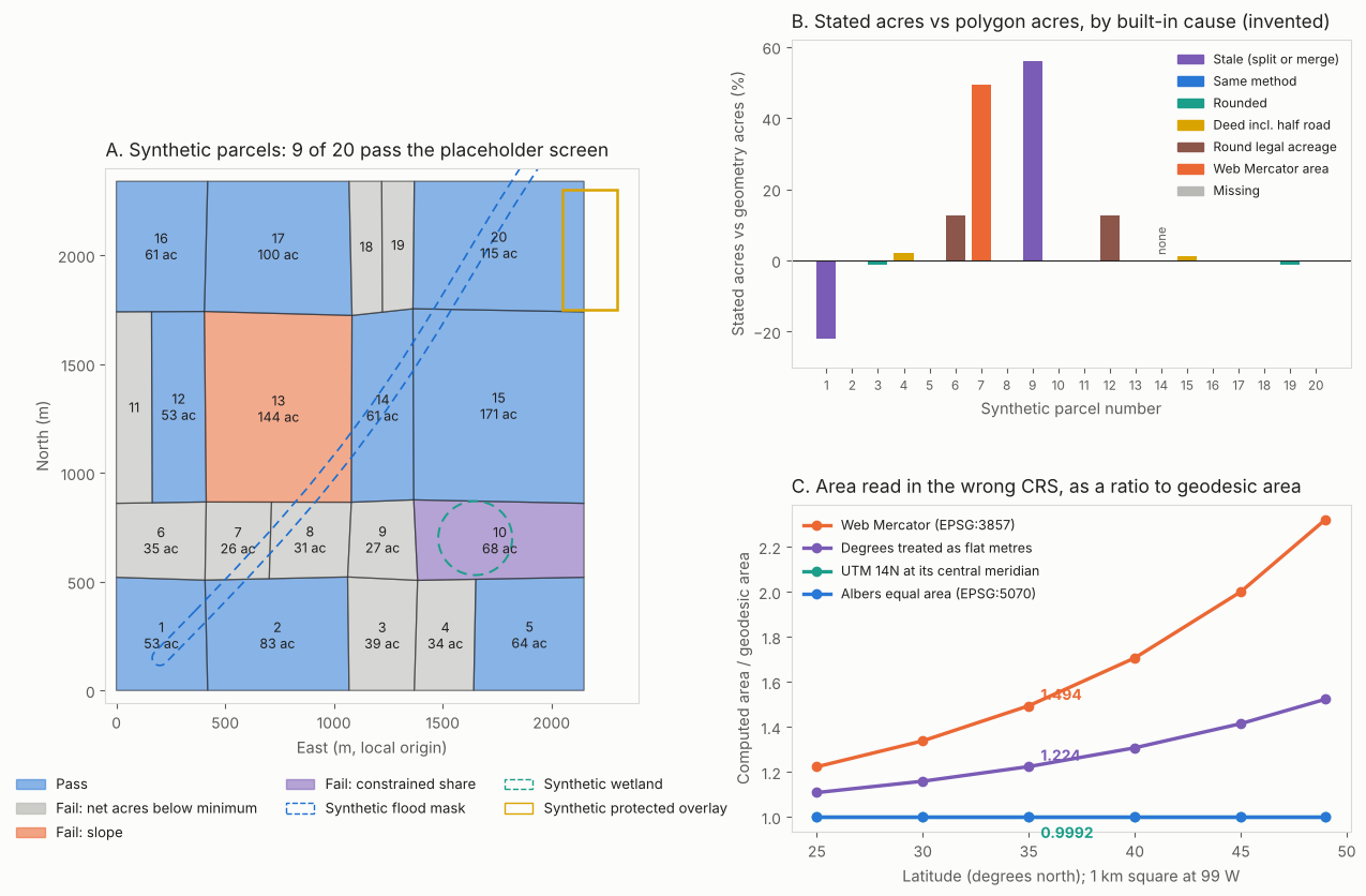
Figure 1. On synthetic parcels, stated acres differ from polygon acres by up to 56%. For a 1 km square at 35°N, Web Mercator inflates area 1.49 times.
Where does parcel data come from?
The US sources in this table start with county or town assessors. State offices, open-data portals and companies then gather that data. They put it in one format.
| Source | What the opened page says | Page date |
|---|---|---|
| County assessor mapping (Snohomish County, WA) | Maps show legal descriptions in the assessment roll, "may be for administrative purposes only", and "do not show ownership". | Undated FAQ |
| State aggregation (MassGIS) | All 351 cities and towns. "an ‘as is’ copy of the records maintained by each assessor". Aggregate files refresh twice a year. Town updates come about monthly. | Updated 29 September 2026 |
| County open data (Lake County, IL) | Updated weekly. The "ONLY attribute included is the Property Index Number". | Catalogue modified 11 October 2026 |
| Open-data survey (Alameda County, CA) | Openly licensed, bulk and free, but "Up-to-date: No", though it says parcel boundaries "are updated each year". No assessor information. | Entry shows file modified 3 February 2018 |
| National registry (HM Land Registry, England and Wales) | Index polygons show the "position and indicative extent of a registered property". Updated monthly. | Last updated 3 July 2020 |
| Commercial aggregator (ReportAll, via PVcase help) | ReportAll "aggregates parcel and ownership information directly from each county". PVcase says it updates 90% of data within 12 months and 70% within 6. | Updated 29 December 2025 |
A boundary-only file needs a join to assessor data to show owner or value. A company file joins them for you but adds its own licence.
What do the main parcel fields mean?
Each field is the county’s record, tidied by the supplier. Regrid’s schema pages show the usual cautions.
| Field | What the documentation says | Caution |
|---|---|---|
| Parcel ID (APN) | Regrid parcelnumb: "The primary parcel ID as provided by the county". | IDs "are not unique nationwide (often not even within a county) and can change between updates". Formatting and spacing vary. |
| Owner | "Local source’s record of parcel owner’s name". | "May not be tracked on public land or rights-of-ways". |
| Acreage | ll_gisacre is "Calculated from parcel geometry". County gisacre is the value "provided by the source". | County acres are "not standardized". deeded_acres Is "often different and separate from acreage calculated by GIS". |
| Zoning | zoning: "Governing municipality’s zoning code". | "Each jurisdiction defines its own codes". Unincorporated areas often have none. |
| Land use | usecode: "County’s own numeric code for property use". | Codes are not comparable between counties. |
| Assessed value | parval: total value "from Assessor’s data". | "Valuation methods vary by state." Some places report assessed value, others market value. Check parvaltype and taxyear. |
How accurate is parcel data?
It is good enough to screen sites. It is not good enough to design one. Three limits matter: boundary position, record age and gaps.
- Boundary position. MassGIS says boundaries may conflict with orthoimagery. Lake County says its layer is "not intended to be used in place of an on-site survey". Both send you to a licensed surveyor for a legal answer.
- Record age. Updates range from weekly (Lake County) to "Up-to-date: No" (the Alameda entry). PVcase warns its "Last Updated" column may not match the provider’s refresh date.
- Gaps. PVcase’s help lists public land, untaxed land and some states that limit property details for civil servants. The help also describes an "Unknown Owner" label.
How much can a boundary error cost? We moved one 500 m edge of a synthetic parcel. The parcel is 400 m by 500 m (49.42 acres).
| Edge offset | Area change (acres) | Area change (%) |
|---|---|---|
| 1 m | 0.12 | 0.25% |
| 3 m | 0.37 | 0.75% |
| 5 m | 0.62 | 1.25% |
| 10 m | 1.24 | 2.50% |
A few metres change acreage by about a percent. An old layer is the bigger risk.
How do you check acreage from a parcel polygon?
Reproject the polygon to an equal-area or local projected CRS. Take its area. Then divide by 4,046.8564224 square metres per acre. Do not read area from degrees or Web Mercator.
- Read the polygon and its CRS from the file metadata. Most downloads are longitude and latitude.
- Reproject to an equal-area CRS such as EPSG:5070 (NAD83 / Conus Albers). A local UTM or state plane zone also works.
- Take the polygon area in square metres.
- Divide by 4,046.8564224. That is 43,560 square feet, with the foot at exactly 0.3048 m (NIST, updated 3 February 2026).
- Compare with the stated acres. Check any difference over your limit.
The US survey acre differs from this acre by 4 parts per million (our sum from NIST’s definitions). That is too small to matter here. Below, pyproj 3.8.0 and shapely 2.2.0 read a 1 km square at 99°W. The reference is the geodesic area on the WGS 84 ellipsoid.
| How the area was read | Ratio to geodesic area |
|---|---|
| Albers equal area (EPSG:5070) | 1.0000 |
| UTM zone 14N, on its central meridian | 0.9992 |
| UTM zone 14N, 3° of longitude from the meridian | 1.0010 |
| Web Mercator (EPSG:3857) at 25°N | 1.223 |
| Web Mercator (EPSG:3857) at 35°N | 1.494 |
| Web Mercator (EPSG:3857) at 49°N | 2.322 |
The Web Mercator rows follow its scale stretch. Area grows by about one over the squared cosine of the latitude, plus a small ellipsoid effect.
Other causes also exist. Six are built into the synthetic set. The Regrid page says only that deed and GIS acres differ, not why.
| Built-in cause | Parcel | Acres: stated / polygon | Stated vs polygon |
|---|---|---|---|
| Rounded to whole acres | 3 | 39.00 / 39.49 | -1.2% |
| Deed area includes half a 20 m road (assumed) | 4 | 34.70 / 34.00 | +2.1% |
| Round legal acreage | 6 | 40.00 / 35.48 | +12.7% |
| Area computed in Web Mercator | 7 | 39.09 / 26.16 | +49.4% |
| Stale after a split (15 acres sold off) | 9 | 41.82 / 26.82 | +56.0% |
| Stale after a merge (11.5 acres added) | 1 | 41.06 / 52.56 | -21.9% |
Parcel 14 had no stated acreage, so only its polygon acres can be used. On a real parcel, compute your own acres and use any county figure as a cross-check.
Worked example: screening 20 synthetic parcels
A screen keeps parcels that pass every test. Our placeholder tests need net acres of at least 40 and mean slope of at most 6%. They also need a constrained share of at most 25% and under 50% in a protected overlay. Net acres equal polygon acres times one minus the constrained share.
| Parcel | Acres: polygon (Albers) / stated (difference) | Slope % / constrained % | Net acres | Result |
|---|---|---|---|---|
| 1 | 52.56 / 41.06 (-21.9%) | 1.7 / 10.9 | 46.8 | Pass |
| 6 | 35.48 / 40.00 (+12.7%) | 2.0 / 0.0 | 35.5 | Fail: net acres |
| 7 | 26.16 / 39.09 (+49.4%) | 2.0 / 15.5 | 22.1 | Fail: net acres |
| 9 | 26.82 / 41.82 (+56.0%) | 1.9 / 0.0 | 26.8 | Fail: net acres |
| 14 | 60.86 / none (no stated acres) | 2.8 / 14.1 | 52.3 | Pass |
Five more parcels follow.
| Parcel | Acres: polygon (Albers) / stated (difference) | Slope % / constrained % | Net acres | Result |
|---|---|---|---|---|
| 10 | 67.93 / 68.00 (+0.1%) | 1.9 / 33.0 | 45.5 | Fail: constrained share |
| 12 | 53.24 / 60.00 (+12.7%) | 5.4 / 0.0 | 53.2 | Pass |
| 13 | 144.25 / 144.25 (0.0%) | 7.0 / 4.1 | 138.4 | Fail: slope |
| 15 | 170.56 / 172.50 (+1.1%) | 2.3 / 2.6 | 166.1 | Pass |
| 20 | 114.84 / 114.84 (0.0%) | 2.7 / 10.4 | 102.9 | Pass |
The two tables show ten of the 20 parcels, including the three that change sides. The totals below count all 20. The ten left out are not shown, and they split the same way on both bases: four pass and six fail. On polygon acres, 9 of 20 parcels pass. On stated acres, 9 also pass, but not the same ones. Parcels 1, 6, 9 change sides. Parcel 14 cannot be screened. A matching count can hide different parcels.
Slope and constraints are example here. For real slope see terrain modelling. For exclusion areas see keep-out zones.
Parcel area calculator
The calculator converts area units, compares stated and polygon areas, and repeats the screen for one parcel on both bases.
What should you know about licences and privacy?
Treat owner names and addresses as personal records. Use them for one site at a time. Read the licence of every file you load. This is general guidance, not legal advice.
- Licences differ. Lake County’s catalogue entry gives only a licence link. The Alameda entry says openly licensed. Regrid’s researcher terms (undated) allow non-commercial use. They bar bulk downloads to third parties. They cover one programme. Commercial terms are not stated on the page read.
- Our practice. Do not build or sell lists of private persons. Pull owners only for parcels in a set site search, keep them only while the project is live, honour opt-outs and check your country’s data-protection and marketing rules.
How solar software handles parcel data
All four tools below show parcel boundaries, and only Regrid is rated Yes on all four fields. Ratings come only from the pages read, listed below the table.
| Tool | Boundaries | Owner | Acreage | Zoning |
|---|---|---|---|---|
| Regrid (data provider) | Yes | Yes | Yes | Yes |
| LandGlide (ReportAll) | Yes | Yes | Not stated | Not stated |
| Aurora Solar | Yes | Not stated | Not stated | Not stated |
| PVcase Prospect | Yes | Yes | Partly | Not stated |
Not stated: the company page we cite does not say. Partly: acreage appears only in a sort example and a filter.
- Regrid (data provider): Support pages, metadata 12 June 2026. Some zoning fields are Premium only.
- LandGlide (ReportAll): Product page, undated. Lists property lines, owner and mailing address, land use and sales history. No accuracy note on the page.
- Aurora Solar: Help "Property Lines", updated 7 November 2025. Lines are "automatically loaded from geospatial data sources" (unnamed) and can be moved.
- PVcase Prospect: Help on parcel data (29 December 2025) and sorting (17 November 2025). ReportAll supplies parcels. Acreage appears in a sort example and a "Buildable area (acres)" filter.
Common mistakes with land parcel data
FAQs
What is an APN?
An APN is the assessor’s parcel number. It is the ID a county gives each parcel. Regrid lists it as "the primary parcel ID as provided by the county". Formatting varies. The same number can occur in another county.
Is parcel data a legal boundary?
No. HM Land Registry’s index polygons show "indicative extent". Snohomish and Lake counties and MassGIS say the same in their own words. In the US cases we read, a licensed surveyor gives the legal answer.
Where can I get free parcel data?
County and state open-data portals are the main free sources. The pages read include Lake County, Illinois (weekly, ID only) and MassGIS (monthly batches). The Alameda entry is free and in bulk, but not up to date. Check fields, age and licence each time.
Does parcel data show zoning reliably?
It shows the code the supplier holds. Codes are local. Regrid says unincorporated areas often have no zoning. Confirm the zone and any overlay with the AHJ before you commit.
Related terms
- GIS: the map software that reads parcel layers.
- Site selection software: tools that screen land.
- Setbacks: distances from the boundary.
Next step: check one real parcel’s stated acres against its polygon area, then see how the best solar site selection software screens many.
Sources
- Fields and companies. Regrid support pages, metadata 12 June 2026: schema, identification, ownership, geometry and area, land use and zoning, assessment and tax. Regrid researcher terms (undated). ReportAll, LandGlide (undated). ReportAll, energy (undated).
- Public sources. MassGIS property tax parcels (updated 29 September 2026). Snohomish County assessor FAQ (undated). Lake County, IL parcels, data.gov catalogue (modified 11 October 2026). Open Knowledge US Cities survey, Alameda County (entry shows file modified 3 February 2018). HM Land Registry INSPIRE index polygons (last updated 3 July 2020).
- Software and units. PVcase help, parcel data (29 December 2025). PVcase help, sort and filter parcels (17 November 2025). PVcase blog (9 December 2024). Aurora help, property lines (7 November 2025). NIST units pages: acre and foot (updated 3 February 2026) and survey foot (updated 18 August 2025).
- Model. Synthetic parcels built with a fixed random seed. Pyproj 3.8.0 and shapely 2.2.0 for area. All parcel numbers are synthetic.
Last updated 30 October 2026. Next scheduled review: 30 January 2027.