Key takeaways
- In 11 opened AHJ checklists (n = 11, not a survey), only array location is listed by all 11. Seven items appear in at least 6 and six in 5 or fewer.
- A checklist lists 3 to 9 of our 13 items, so one town’s list is a poor guide to another’s. North arrow appears in 3 of 11, scale or dimensions in 4 of 11.
- Our sample plan, which shows 9 of the 13 items, fully meets 5 of the 11 checklists. It scores 56% to 100% (hypothetical plan, our coding).
- A sheet printed at 90% reads every length 10% short. On our example plan, a 4.0 ft offset reads 3.6 ft (example inputs).
- Of six tools checked, two describe a site plan sheet’s contents and two document a sheet in part. For two, no page read documents one.
To generate a site plan sheet from the design in software, see the best solar permitting software. If you outsource the drawing, see the best solar plan set services.
Site plan at a glance
A site plan is one sheet of a permit set. Each AHJ sets its contents, and no single standard names the items.
| Item | Detail |
|---|---|
| Drawn to scale | The sheet states how many real feet one printed inch stands for |
| Unit / typical range | Feet and inches, or metres and millimetres. Our 11 checklists list 3 to 9 items each |
| Where it matters | AHJ plan review, fire review (Albuquerque lists Fire Department site plan items) and field inspection |
| Standard or rule | No single standard. The AHJ’s checklist and adopted codes decide |
| In software | Generated as a sheet by some design tools, or drawn in CAD |
Why does the site plan matter for installers?
The site plan is where a reviewer checks the array against the lot and the equipment against the buildings. A missing item can mean a correction round. See the permit plan set page for the other sheets and review times.
Checklists differ a lot. Scottsdale asks for easements drawn with dashed lines, and Reno accepts a CAD or line drawing. Copying last month’s sheet for a new town can miss an item.
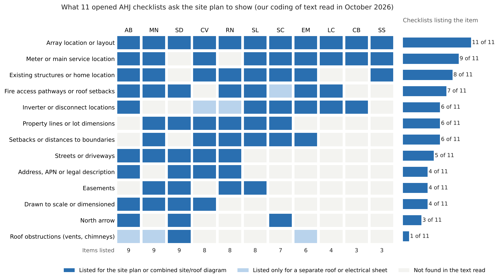
Figure 1. Only array location appears in all 11 opened checklists. Seven items appear in at least 6 and six in 5 or fewer.
What does a solar site plan show?
A site plan shows the lot, the buildings, the array and the equipment, drawn to scale from above. Which items are required is the AHJ’s call.
- Lot: property lines and dimensions, plus the address or parcel number. Some AHJs add streets, driveways and easements. Aurora’s help says it needs property lines for its site plan page.
- Buildings: existing structures and their distances to the lot lines. Roof-edge and fire setbacks have their own page: fire setbacks.
- Array: its location and extents, from the panel layout. Vents and chimneys sit on the roof plan: see keep-out zones.
- Equipment: inverter, disconnects, meters and the main service. The single line diagram shows how they connect, and the site plan shows where they sit. Santa Clara says the rapid shutdown initiator location "shall be shown on the site plan drawing".
- Drawing details: north arrow, scale or dimensions, and labels.
Measurements come from the site survey, roof measurement or an orthomosaic. Check GIS parcel lines against a survey. Minneapolis asks for a survey or found property pins on ground mounts.
What do AHJs ask for? Eleven checklists compared
In our 11 checklists, array location is the only item all of them list. The table counts each item once per checklist.
Documents were read in October 2026 for site plan items. "Site plan" means the item is listed under the site plan heading, in the combined site and roof diagram, or in the same requirement as the site diagram. Conditional wording such as "if required" still counts. "Sheet only" means only a separate roof or electrical sheet lists it. A twelfth document, Houston’s SolarAPP+ guideline, gave no site plan text. It sits outside the 11 and has no code. See the AHJ page.
The codes used below are:
| Code | Jurisdiction and document (date as printed) |
|---|---|
| SC | Santa Clara, CA: expedited PV permitting guide (file name says Revised 07-2023) |
| LC | Larimer County, CO: submittal guidelines (Updated November 2023) and arrays checklist (Updated January 2026), one PDF |
| RN | Reno, NV: residential guidelines (V3.1 4.12.2023). Checked again in November 2026, this link no longer resolves. Confirm current requirements on Reno’s building permit pages. |
| MN | Minneapolis, MN: solar checklist (Last Updated 02/2026) |
| AB | Albuquerque, NM: roof-mounted PV checklist (Revised April 2014) |
And:
| Code | Jurisdiction and document (date as printed) |
|---|---|
| SL | Southlake, TX: PV checklist (Mar 2026) |
| SS | Saratoga Springs, UT: residential checklist (no date). Checked again in November 2026, this link now 404s. Confirm current requirements with the city. |
| CB | Carlsbad, CA: Form B-13 (REV: August 2022) |
| EM | Eagle Mountain, UT: residential checklist (no date) |
| SD | Scottsdale, AZ: residential guidelines (Revised 7-27-20) |
| CV | Chula Vista, CA: Form 4613 (Rev 5.23) |
This is a small, non-random sample. Do not read the counts as national rates. Albuquerque (April 2014) and Scottsdale (7-27-20) are old, and two documents print no date. Always use your AHJ’s current form.
Seven items that most checklists list. Sheet only counts checklists that list an item only on a roof or electrical sheet.
| Item | Site plan (of 11) | Checklists that list it | Sheet only |
|---|---|---|---|
| Array location or layout | 11 | All 11 | 0 |
| Meter or main service location | 9 | SC, LC, MN, AB, SL, SS, CB, EM, CV | 0 |
| Existing structures or home location | 8 | SC, RN, MN, AB, SL, SS, EM, CV | 0 |
| Fire access pathways or roof setbacks | 7 | LC, RN, MN, AB, SL, EM, SD | 1 (SC) |
| Inverter or disconnect locations | 6 | SC, LC, AB, SL, CB, EM | 2 (RN, CV) |
| Property lines or lot dimensions | 6 | SC, RN, MN, SL, SD, CV | 0 |
| Setbacks or distances to boundaries | 6 | SC, RN, MN, SL, EM, CV | 0 |
Six items that fewer checklists list.
| Item | Site plan (of 11) | Checklists that list it | Sheet only |
|---|---|---|---|
| Streets or driveways | 5 | RN, MN, AB, SD, CV | 0 |
| Address, APN or legal description | 4 | RN, AB, SD, CV | 0 |
| Easements | 4 | RN, MN, SL, SD | 0 |
| Drawn to scale or dimensioned | 4 | MN, AB, SD, CV | 0 |
| North arrow | 3 | SC, AB, SD | 0 |
| Roof obstructions (vents, chimneys) | 1 | SD | 3 (MN, AB, EM) |
Worked example: a checklist-completeness scorer
A scorer divides the items a checklist lists by the items your plan shows. Our hypothetical plan P shows nine items. They are property lines, setbacks, structures, array, access pathways, inverter or disconnect, meter, north arrow and scale. It omits four.
| Code | Items listed | Plan P shows | Plan P is missing | Score |
|---|---|---|---|---|
| SC | 7 | 7 | none | 100% |
| LC | 4 | 4 | none | 100% |
| RN | 8 | 5 | easements, streets or driveways, address, APN or legal description | 63% |
| MN | 9 | 7 | easements, streets or driveways | 78% |
| AB | 9 | 7 | streets or driveways, address, APN or legal description | 78% |
| SL | 8 | 7 | easements | 88% |
The other five checklists:
| Code | Items listed | Plan P shows | Plan P is missing | Score |
|---|---|---|---|---|
| SS | 3 | 3 | none | 100% |
| CB | 3 | 3 | none | 100% |
| EM | 6 | 6 | none | 100% |
| SD | 9 | 5 | easements, streets or driveways, address, APN or legal description, roof obstructions (vents, chimneys) | 56% |
| CV | 8 | 6 | streets or driveways, address, APN or legal description | 75% |
Five checklists are fully met. The lowest score is 56% (Scottsdale), and the highest is 100%. The gaps are streets (5 checklists), easements (4), address (4) and roof obstructions (1). Only items coded for the site plan count, and every item has equal weight.
How do you check scale and offsets on a printed plan?
Convert each printed length to a real length with the scale, correcting for the print size. Then compare the offsets with the minimum your AHJ gives.
- Print or view the sheet at its stated size. If it was shrunk to fit the page, note the print size in percent.
- Measure the lot, the array box and each offset on the sheet.
- Divide each length by the print size as a fraction, then multiply by the scale.
- Check that left offset, array and right offset add up to the lot width. Do the same for depth.
- Compare each offset with your AHJ’s minimum.
The formula is: real length = printed length ÷ (print size ÷ 100) × scale. At 1 in = 20 ft (1:240), 1.575 in prints as 31.5 ft.
Our example plan uses 1 in = 20 ft (1:240). The lot is 70 ft by 110 ft and the array box is 31.5 ft by 14.0 ft. All distances are our example inputs. The 5 ft minimum offset is a placeholder, not a rule.
| Measurement | Printed (in) | Real (ft) | Against 5 ft placeholder |
|---|---|---|---|
| Lot width | 3.500 | 70.0 | - |
| Lot depth | 5.500 | 110.0 | - |
| Array box width | 1.575 | 31.5 | - |
| Array box depth | 0.700 | 14.0 | - |
| Offset, left line | 0.200 | 4.0 | Below |
| Offset, right line | 1.725 | 34.5 | Meets |
| Offset, front line | 1.900 | 38.0 | Meets |
| Offset, rear line | 2.900 | 58.0 | Meets |
The offsets close: 4.0 + 31.5 + 34.5 = 70.0 ft, and 38.0 + 14.0 + 58.0 = 110.0 ft. Now print the same sheet at 90%. Every length shrinks by 10%. Read as 100%, the lot width reads 63.0 ft, not the labelled 70 ft. The left offset reads 3.6 ft.
The scale also sets reading precision. At 1 in = 20 ft, a reading good to 1/32 in means 0.63 ft. At 1/4 in = 1 ft it means 0.13 ft. On a 4.0 ft offset that is 15.6% against 3.1%. Chula Vista calls 1/4 in = 1 ft preferable.
Site plan scale and offset calculator
Part A converts one printed length. Part B converts the lot, array box and four offsets. It checks they close and compares each offset with a minimum you enter. Presets reproduce the table above. It is arithmetic, not a code check.
How solar software handles the site plan
Only Aurora and Solargraf describe what their site plan sheet contains, such as property lines and distances. SolarDesignTool and OpenSolar document a sheet but not its contents, so both are rated Partly (checked October 2026). Partly means the page names the sheet or its inputs but not its contents.
| Software | Documents a site plan sheet? |
|---|---|
| Aurora Solar | Yes |
| Solargraf | Yes |
| SolarDesignTool | Partly |
| OpenSolar | Partly |
| Scanifly | Not stated |
| SolarEdge Designer | Not stated |
- Aurora Solar: Instant Plan Sets use property lines for the site plan page. Base maps: None, Aerial or Street. Options add parcel boundary distance lines and a gas meter clearance note. No scale, north arrow or setbacks named for the site plan. Fire pathways sit on another page. Help article, updated 27 January 2026.
- Solargraf: Lists "Site and roof plan" in the permit plan. It must show property lines with dimensions, distance to the house, modules and eBOS placement. No north arrow mentioned. Vicinity markers: "Add manually if applicable". Guidelines article 23 April 2024. PDF and DWG from FAQ, 9 September 2024.
- SolarDesignTool: Each permit package contains a site plan, described as "a detailed overview of the system and the entire site". Contents not described. No date on the permits page or the press release page.
- OpenSolar: A help article covers a PV Site Information Plan. It lists inputs: design, annotations, cable length, string configurations and installation date. The text read does not describe the sheet’s contents, scale or north arrow. Last update shown 5 May 2026.
- Scanifly: Two pages read mention AHJ-approved plan sets and stamps in under 48 hours, and racking layout sync. Neither names a site plan sheet. Pages scanifly.com/?p=93 and ?p=8740 (metadata dates June and September 2026).
- SolarEdge Designer: No company page read covers site plan output. This is not a claim that it has none. The company press page tried is not among the pages read.
Not stated means no page read documents a site plan sheet for that tool. It is not a claim that the tool has none. The best solar permitting software list covers the wider field.
Common mistakes with site plans
FAQs
What is the difference between a site plan and a roof plan?
The site plan shows the lot and where things sit on it. The roof plan shows the roof layout, modules, pathways and labels. Santa Clara, Minneapolis and Carlsbad list them separately. Larimer County asks for one site and roof diagram.
Does a site plan need a north arrow and a scale?
Only if your AHJ’s checklist lists them. In our 11 checklists, 3 list a north arrow and 4 ask for a scale or dimensions. The rest are silent in the text we read. Scottsdale says "North Arrow & Bar Scale" for roof-mounted systems.
What scale should a solar site plan use?
Use the scale your AHJ names. Scottsdale’s guidelines say the allowed scale is 1 in = 20 ft minimum. Chula Vista’s form says it must be drawn to scale and calls 1/4 in = 1 ft preferable.
Can I use a drone or satellite image as the site plan?
Sometimes, if the AHJ accepts it. Reno says no to Google Earth type maps. Aurora offers an aerial base map style with modules superimposed. An orthomosaic can give a measured base, but the reviewer decides what to accept.
Related terms
- Permit plan set: the full set of sheets that includes the site plan.
- Fire setback: a roof strip kept free of modules.
- Keep-out zone: an area where no modules go.
- Single line diagram: the electrical sheet that pairs with the site plan.
- Authority having jurisdiction: the body that reviews the plan.
- SolarAPP+: an online platform that automates permit review.
Next step: score your own sheet against your AHJ’s current checklist, then check its print scale in the calculator above before you submit it.
Sources
- The 11 AHJ documents are linked in the key above (checked October 2026). Scottsdale and Chula Vista scale wording re-read on 30 October 2026.
- Aurora help: Instant Plan Sets (checked October 2026).
- Solargraf help: Self Service Permit Guidelines and plan set FAQs (checked October 2026).
- SolarDesignTool permits page and press release (checked October 2026).
- OpenSolar: Generate a PV Site Information Plan (checked October 2026).
- Scanifly and Scanifly integration page (checked October 2026).
Last updated 3 November 2026. Next scheduled review: 3 February 2027.